Evacuation Expanded
February 11, 2026
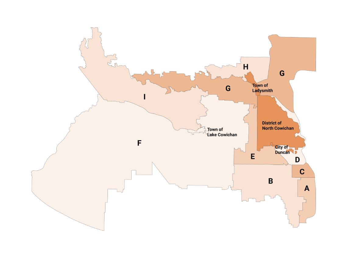
As a result of warmer temperatures and increased precipitation, there is localized flooding near several watersheds including the Koksilah River, Cowichan River, Lake Cowichan and the Chemainus River. There are high water levels in several areas and flooding has caused evacuation in several communities.
As a result of warmer temperatures and increased precipitation, there is localized flooding near several watersheds including the Koksilah River, Cowichan River, Lake Cowichan and the Chemainus River. There are high water levels in several areas and flooding has caused evacuation in several communities.
As a result of warmer temperatures and increased precipitation, there is localized flooding near several watersheds including the Koksilah River, Cowichan River, Lake Cowichan and the Chemainus River. There are high water levels in several areas and flooding has caused evacuation in several communities.
As a result of warmer temperatures and increased precipitation, there is localized flooding near several watersheds including the Koksilah River, Cowichan River, Lake Cowichan and the Chemainus River. There are high water levels in several areas and flooding has caused evacuation in several communities.
As a result of warmer temperatures and increased precipitation, there is localized flooding near several watersheds including the Koksilah River, Cowichan River, Lake Cowichan and the Chemainus River. There are high water levels in several areas and flooding has caused evacuation in several communities.
As a result of warmer temperatures and increased precipitation, there is localized flooding near several watersheds including the Koksilah River, Cowichan River, Lake Cowichan and the Chemainus River. There are high water levels in several areas and flooding has caused evacuation in several communities.
As a result of warmer temperatures and increased precipitation, there is localized flooding near several watersheds including the Koksilah River, Cowichan River, Lake Cowichan and the Chemainus River. There are high water levels in several areas and flooding has caused evacuation in several communities.
As a result of warmer temperatures and increased precipitation, there is localized flooding near several watersheds including the Koksilah River, Cowichan River, Lake Cowichan and the Chemainus River. There are high water levels in several areas and flooding has caused evacuation in several communities.
As a result of warmer temperatures and increased precipitation, there is localized flooding near several watersheds including the Koksilah River, Cowichan River, Lake Cowichan and the Chemainus River. There are high water levels in several areas and flooding has caused evacuation in several communities.
As a result of warmer temperatures and increased precipitation, there is localized flooding near several watersheds including the Koksilah River, Cowichan River, Lake Cowichan and the Chemainus River. There are high water levels in several areas and flooding has caused evacuation in several communities.
As a result of warmer temperatures and increased precipitation, there is localized flooding near several watersheds including the Koksilah River, Cowichan River, Lake Cowichan and the Chemainus River. There are high water levels in several areas and flooding has caused evacuation in several communities.
As a result of warmer temperatures and increased precipitation, there is localized flooding near several watersheds including the Koksilah River, Cowichan River, Lake Cowichan and the Chemainus River. There are high water levels in several areas and flooding has caused evacuation in several communities.
As a result of warmer temperatures and increased precipitation, there is localized flooding near several watersheds including the Koksilah River, Cowichan River, Lake Cowichan and the Chemainus River. There are high water levels in several areas and flooding has caused evacuation in several communities.
As a result of warmer temperatures and increased precipitation, there is localized flooding near several watersheds including the Koksilah River, Cowichan River, Lake Cowichan and the Chemainus River. There are high water levels in several areas and flooding has caused evacuation in several communities.
As a result of warmer temperatures and increased precipitation, there is localized flooding near several watersheds including the Koksilah River, Cowichan River, Lake Cowichan and the Chemainus River. There are high water levels in several areas and flooding has caused evacuation in several communities.
As a result of warmer temperatures and increased precipitation, there is localized flooding near several watersheds including the Koksilah River, Cowichan River, Lake Cowichan and the Chemainus River. There are high water levels in several areas and flooding has caused evacuation in several communities.
As a result of warmer temperatures and increased precipitation, there is localized flooding near several watersheds including the Koksilah River, Cowichan River, Lake Cowichan and the Chemainus River. There are high water levels in several areas and flooding has caused evacuation in several communities.
As a result of warmer temperatures and increased precipitation, there is localized flooding near several watersheds including the Koksilah River, Cowichan River, Lake Cowichan and the Chemainus River. There are high water levels in several areas and flooding has caused evacuation in several communities.
As a result of warmer temperatures and increased precipitation, there is localized flooding near several watersheds including the Koksilah River, Cowichan River, Lake Cowichan and the Chemainus River. There are high water levels in several areas and flooding has caused evacuation in several communities.
As a result of warmer temperatures and increased precipitation, there is localized flooding near several watersheds including the Koksilah River, Cowichan River, Lake Cowichan and the Chemainus River. There are high water levels in several areas and flooding has caused evacuation in several communities.
As a result of warmer temperatures and increased precipitation, there is localized flooding near several watersheds including the Koksilah River, Cowichan River, Lake Cowichan and the Chemainus River. There are high water levels in several areas and flooding has caused evacuation in several communities.